|
Importance of the Bay
Based on information contained in the Town of North Hempstead's preliminary draft Local Waterfront Revitalization Plan (Cashin, 1993), Manhasset Bay is used extensively for a variety of recreational activities that include boating, rowing, some limited swimming, fishing, shoreline walking, waterfront dining, dinner boat cruises and water taxis. The nautical character of portions of the Bay also provides aesthetically pleasing shorefront viewing. The following is a brief discussion of the uses and ecological features of the Bay based on information contained in the preliminary draft Local Waterfront Revitalization Plan.
Boating
Moorings and marinas occupy a large and prominent portion of Manhasset Bay, but recreational boating has seen a precipitous decline since this study was done in the 1990s. Charter fishing and dinner boats have become a new mainstay in the Bay, as have water taxis as a means of boosting tourism in the Bay and the local economy. The water taxis, which run between various docks are an attempt by local businesses to make it easier for residents and visitors to move between water, land, restaurants and shops.
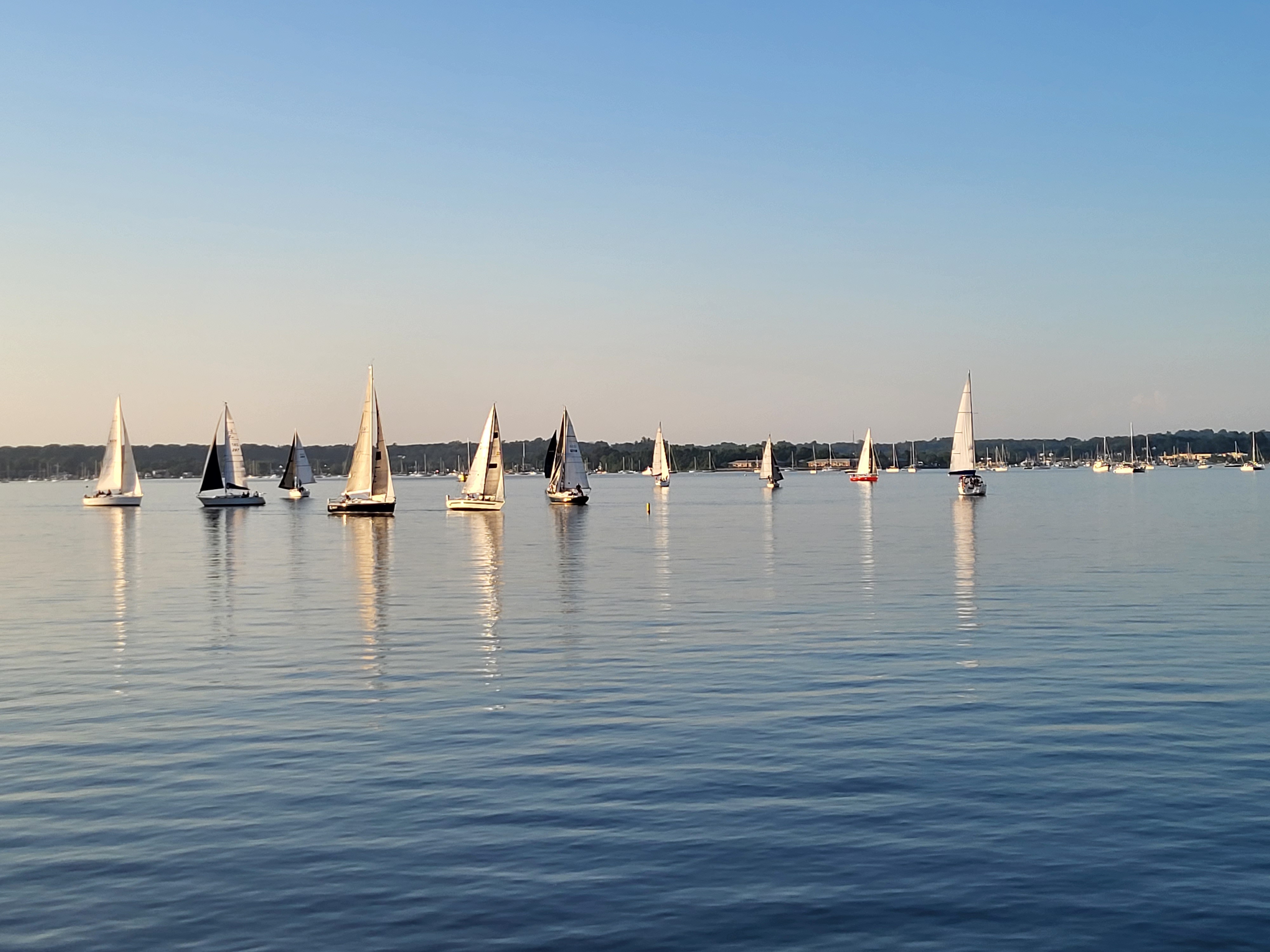
Credit: K. Siegel
Fishing and Shellfishing
Manhasset Bay is a productive area for marine finfish with recreational fishing being a popular sport both within the Bay and in the nearby waters of the Long Island Sound. Small boats can be rented on a daily basis from a few private businesses located in the vicinity of the Town of North Hempstead Town dock. The Bay serves as a nursery and feeding area from spring through fall for striped bass, scup, bluefish, Atlantic silverside, menhaden, winter flounder, and blackfish.
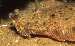
winter flounder (Pseudopleorunectes americanus)
It is illegal to remove shellfish from Manhasset Bay for any reason, including bait. If you see someone removing shellfish from Manhasset Bay, please call DEC's Division of Law Enforcement for Nassau and Suffolk at 631-444-0250 or the 24-hour dispatch at 1-844-DEC-ECOs (1-844-332-3267).
The direct harvest of shellfish from Manhasset Bay has been prohibited by the State since the early 1970s due to the bacterial levels in the Bay exceeding the State's water quality standards for shellfishing. Degraded bacterial water quality in the Bay has existed since the 1920s and has been attributed in large part to increased development. In fact, in 1925, the State closed 2,500 acres (essentially the entire Bay) of oyster beds. The closure was due to an outbreak of typhoid that was linked to oysters that had been taken from the Bay. These early problems were experienced in spite of the construction of a wastewater treatment plant in Port Washington almost a decade earlier.
In the early 1990s, the Town conducted a one time clam transplanting/relay program, in cooperation with NYSDEC, for harvest, transport and depuration. Indications from the State are that it is unlikely to allow harvesting in the near future, because of excessive levels of coliform, particularly after rainfall.
Wildlife
According to the New York State's Coastal Fish and Wildlife Habitat Rating Form, Manhasset Bay is one of five major waterfowl wintering areas (November through March) on Long Island's north shore. Mid-winter aerial surveys of waterfowl abundance for the 10 year period 1975 to 1984 indicate yearly average concentrations of over 1,100 birds. This includes scaup, canvasbacks and black ducks, along with mallards, Canada goose, common goldeneye, bufflehead, oldsquaw and red-breasted merganser.
The tidal flats and intertidal marsh areas in the Bay support a large summer population of wading shorebirds and waterfowl including: Mute Swans; Common Egrets; Snowy Egrets; Double-crested Cormorants; Great Blue Herons; Least Sandpipers; Sanderlings; Mallards; Laughing Gulls; and Herring Gulls. The entire Manhasset Bay area has been designated by the New York State Department of State (NYSDOS) as a Significant Coastal Fish and Wildlife Habitat. In addition, the area is important for passive recreational use for wildlife/bird watching.
Wetlands and Special Habitats
Wetlands are an important part of the Manhasset Bay ecosystem serving numerous functions. While there are many definitions for what constitutes wetlands, one definition is that of the U.S. Army Corps of Engineers (USCOE, 1995) which states that wetlands are those areas that are inundated or saturated by surface or groundwater at a frequency and duration sufficient to support, and that under normal circumstances do support, a prevalence of vegetation typically adopted for life in saturated soil conditions. Wetlands generally include swamps, marshes, bogs and similar areas. In recent years, the importance of the functions and values associated with wetlands have been recognized. See Table 1.3-2.
The degree of public interest in protecting, restoring and creating wetlands has grown significantly to the point that today there is a heightened educational awareness of the importance of wetlands.
Table 1.3-2
FUNCTIONS OF WETLANDS*
|
Function
|
Description
|
|
Groundwater Recharge/Discharge
|
This function considers the potential for a wetland to serve as a groundwater recharge and/or discharge area. Recharge should relate to the potential for the wetland to contribute water to an aquifer. Discharge should relate to the potential for the wetland to serve as an area where groundwater can be discharged to the surface.
|
|
Floodflow Alteration
(Storage and Desynchronization)
|
This function considers the effectiveness of the wetland in reducing flood damage by attenuation of floodwaters for prolonged periods following precipitation events.
|
|
Fish and Shellfish Habitat
|
This function considers the effectiveness of seasonal or permanent waterbodies associated with the wetland in question for fish and shellfish habitat.
|
|
Sediment/Toxicant/Pathogen Retention
|
This function reduces or prevents degradation of water quality. It related to the effectiveness of the wetland as a trap for sediments, toxicants or pathogens.
|
|
Nutrient Removal/Retention/
Transformation
|
This function relates to the effectiveness of the wetland to prevent adverse effects of excess nutrients entering aquifers or surface waters such as ponds, lakes, streams, rivers or estuaries.
|
|
Production Export (Nutrient)
|
This function relates to the effectiveness of the wetland to produce food or usable products for human or other living organisms.
|
|
Sediment/Shoreline Stabilization
|
This function relates to the effectiveness of a wetland to stabilize stream banks and shorelines against erosion.
|
|
Wildlife Habitat
|
This function considers the effectiveness of the wetland to provide habitat for various types and populations of animals typically associated with wetlands and the wetland edge. Both resident and/or migrating species must be considered. Species lists of observed and potential animals should be included in the wetland assessment report.
|
VALUES OF WETLANDS*
|
Value
|
Description
|
|
Recreation (Consumptive and Nonconsumptive)
|
This value considers the effectiveness of the wetland and associated watercourses to provide recreational opportunities such as canoeing, boating, fishing, hunting and other active or passive recreational activities. Consumptive opportunities consume or diminish the plants, animals or other resources that are intrinsic to the wetland, whereas nonconsumptive opportunities do not.
|
|
Education/Scientific Value
|
This value considers the effectiveness of the wetland as a site for an "outdoor classroom" or as a location for scientific study or research.
|
|
Uniqueness/Heritage
|
This value relates to the effectiveness of the wetland or its associated waterbodies to produce certain special values. Special values may include such things as archeological sites, unusual aesthetic quality, historical events, or unique plants, animals or geologic features, etc.
|
|
Visual Quality/Aesthetics
|
This value relates to the visual and aesthetic qualities of the wetland.
|
|
Threatened or Endangered Species Habitat
|
This value relates to the effectiveness of the wetland or associated waterbodies to support threatened or endangered species.
|
*Based on U.S. Army Corps of Engineers, November 1995.
The United States Department of the Interior's Fish and Wildlife Service (FWS) maintains a national wetlands inventory of both freshwater and marine wetlands. A review of this information indicates that there are numerous clusters and small patches of wetlands in the watershed. Based on the U.S. Department of the Interior's 1994 National Wetlands Inventory by FWS, and except for a few isolated patches, most of the wetlands are found clustered in six general areas. These general areas are:
North and East Sheets Creek, Mill Pond and Baxter Pond
Leeds Pond and portions of its tributary streams
Whitney Pond and portions of its tributary stream
Twin Ponds (South Pond/Mann's Creek)
Mitchell Creek and Kings Point Park
Kings Point Pond (Wilson's Creek)
A number of bulkheads, seawalls and revetments have been constructed along various sections of the Bay's shoreline. In some of these sections, the vegetated areas of intertidal wetland have been reduced to isolated patches and narrow fringes generally bordering the protected southern side of coastal structures.
|